UK maps of radon
Radon address search
A report will tell you the estimated probability above the Action Level.
Order a reportRadon measurement pack
Find out the yearly average radon level for a property and if it is above or below the Action Level.
Order a domestic pack Order a workplace packEverything you need to know about radon
Radon is a colourless, odourless radioactive gas formed by the radioactive decay of the small amounts of uranium that occur naturally in all rocks and soils.
UKHSA has published reports containing radon Affected Area maps for the whole of the United Kingdom. Copies of the reports are available in resources.
UKHSA updated the radon map on 22/10/2025 to include the Isle Of Man. You can view the press release regarding the new radon map data here.
UKHSA launched the new radon map on 01/12/22 - some users have experienced issues due to the cached data on their web browser. If you clear your history for cached data and images and re-visit the website this should load. You can view the press release regarding the new radon map data here
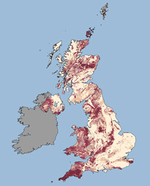
Every building contains radon but the levels are usually low. The chances of a higher level depend on the type of ground. UK Health Security Agency has published a map showing where high levels are more likely.
The darker the colour the greater the chance of a higher level. The chance is less than one home in a hundred in the white areas and greater than one in three in the darkest areas.
The map should not be used for basements, cellars or underground sites, all of which should be considered as having an increased chance of high radon levels, regardless of location.